

Au Sable River Highbanks
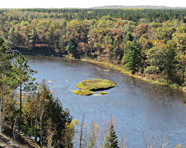
World famous for trout fishing, the Au Sable River runs more than 100 miles through some of the most beautiful wilderness in lower Michigan before flowing into into Lake Huron. Far up atop the bluffs along the river the Au Sable Highbanks Trail affords some of the most spectacular scenic views in Northern Michigan.
The trail runs some seven miles along the Au Sable River Valley. There are access points to this ski/hike trail 15 miles outside of Oscoda at the areas at Iargo Springs and the Lumberman's Monument. In the height of the season, these areas will often be crowded with tourists. The noise of people and traffic tend to diminish the experience to be found in this beautiful wilderness. However, there is an uncrowded spot where you can access one of the most beautiful sections of the highbanks and enjoy a short walk along the bluffs.
You can park at the junction of the Au Sable Road and USFS Road 3993, to avoid driving on gravel and walk in, or you can drive in on 3993 to the parking area. If you decide to walk in, you will immediately enter the towering pines and mixed hardwood trees, of the Huron National Forest. The path to the bluffs isn't very long and it will only take a short time to reach the split rail fence that runs along this section of the Highbanks Trail. The fence runs along an overlook that is more than 100 feet above the river.
At the overlook you can simply pause, rest, and take in the breathtaking view of the bend, in the Au Sable River, spread out below. A gentle pathway runs along the top of the bluff in both directions for short distances to get even more perspectives on the river valley. Needless to say, this is a spot cherished by photographers during color tour time. For the adventurous and those in good physical condition, there is a stairway that winds down the bluff all the way to the river. It is a long way down, but well worth it if you have the energy. During the warm months you may well encounter hikers doing the whole seven miles, also fishermen, and paddlers on the river. In the winter, you might be the only person taking in the pure air, high up on the bluffs.
Important Notes: The Au Sable Highbanks Trail is open year-round. There is no fee required to use the trail.